413 KM | Best for first-time visitors
Waterfalls Route
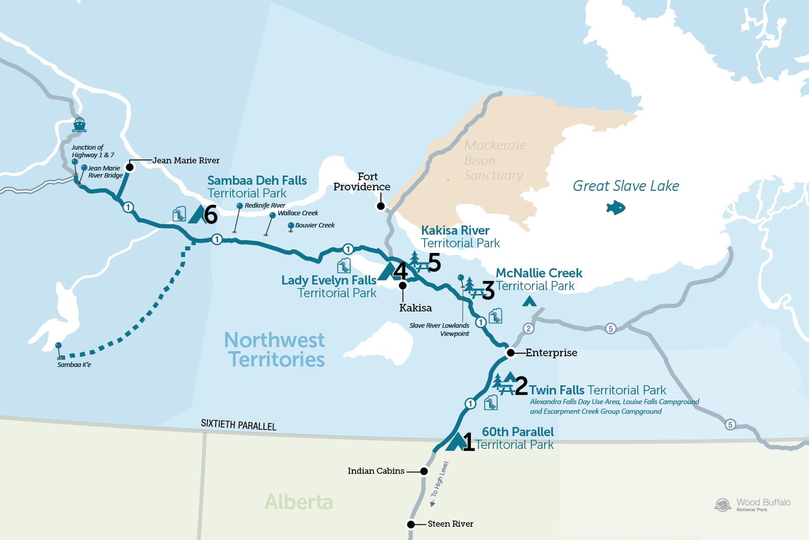
Embark on a breathtaking adventure along the Waterfalls Route. Starting at the 60th parallel, this scenic journey takes you from the Northwest Territories/Alberta border to Checkpoint at the junction of Highways 1 and 7. It showcases a series of spectacular waterfalls, pristine rivers, sandy beaches, and serene lakes.
Experience the natural beauty of the Northwest Territories with stops at territorial campgrounds nestled in wilderness settings and explore charming communities, such as Enterprise and Kakisa along the route. This route follows the Mackenzie Highway, where you will see signs with the symbols of a knife and quill. The knife represents the Indigenous hunting and trapping heritage, and the quill symbolizes the first historical records by the famous explorer Sir Alexander Mackenzie, who visited the area over 200 years ago. The Highway was built in 1942 and is named in his honour.
Kilometres reflect distance from the NWT/Alberta border, not total driving distance.
Route Detail
The 60th Parallel
60th Parallel Territorial Park and Visitor Information Centre
The Visitor Information Centre is open from mid-May to mid-September, and staff are ready to welcome you to the NWT with coffee, maps, travel brochures, and restrooms. Indigenous arts and crafts are on display and wildlife displays depict the northern fauna in the region. Make sure to ask for your "North of 60" Certificate and take a photograph with the 60th Parallel sign to commemorate your journey past the iconic landmark.
Adjacent to the information centre, this territorial park has 9 non-powered campsites nestled amongst birch and aspen trees, and a scenic picnic area overlooking the beautiful Hay River.
Of Special Interest
A historic marker commemorates the completion of the Great Slave Lake Railway.


Twin Falls Territorial Park
Twin Falls Territorial Park
With three day-use and camping areas linked by a walking trail, Twin Falls Territorial Park is a breathtaking park well worth the visit. One of the Territories' most popular parks, the twin waterfalls - Louise Falls (15m) and Alexandra Falls (32m) - and the two-kilometre trail that connects them are the centrepiece of this region. Enjoy dizzying views of the falls from several safe viewing points or climb the 138-step spiral staircase that takes you down to the lip of Louise Falls.
Of Special Interest
There are many natural hazards within the Twin Falls Gorge Territorial Park (unstable cliffs, uneven surfaces, dangerous currents, slippery surfaces). Please exercise caution while enjoying this Territorial Park.


Alexandra Falls Day Use Area
A dramatically beautiful spot to enjoy a picnic, stroll the boardwalk to Louise Falls or watch Alexandra Falls tumble 32 metres over the Hay River. View the magnificent falls from either of two viewing platforms a short walk away.

Louise Falls Campground
Louise Falls offers 28 powered campsites surrounded by jack pines, spectacular flora and 400-million-year-old limestone formations along the Hay River Gorge. A unique 138-step spiral staircase leads down an embankment to a viewpoint overlooking the three-tiered Louise Falls.

Escarpment Creek Group Camping Area
There are 12 powered campsites, a kitchen shelter with woodstove and three tables well-equipped for group camping as well as space for day use activities. An attractive series of small waterfalls adorn this deep gorge of the Hay River.
The Junction
Enterprise
Enterprise is the premier community after the 60th Parallel. Located at the junction of Highways 1 and 2, Enterprise (population 102) is the first community on the Waterfalls Route. A significant point on the NWT highway system, Enterprise is at an important junction of the Mackenzie Highway and the road to Yellowknife.
Of Special Interest
There are reduced visitor services in the community following the effects of a wildfire in 2023. The community does offer a fueling station and the friendly staff at the hamlet office (on Robin Road) are happy to answer questions and provide information.
Junction of Highways 1 and 2
Keep left on Highway 1 to continue the Waterfalls Route. To the right, Highway 2 leads to Hay River and Fort Resolution (Great Slave Route) and to Fort Smith (Wood Buffalo Route).
McNallie Creek Territorial Park Day Use Area
Postcard-perfect Views
A small rest stop and picnic area with a short trail leading to the 17-metre McNallie Creek Falls. Look for the darting cliff swallows nesting in the ravine walls.
Of Special Interest
There is no infrastructure or guard rails at the look out point in the park following the 2023 wildfire. Please exercise caution while the park facilities are being rebuilt.

Slave River Lowlands Overview
Take in the view of the Slave River lowlands as they roll north and west to the shores of Great Slave Lake. On clear days, you can also see the only high-rise building in Hay River, which is over 50 km away.

Lady Evelyn Falls Territorial Park
Dramatic Waterfalls
Take the access road to the south off Highway 1 for 6.8 km to arrive at the park.
This park has 23 powered campsites. The dramatic Lady Evelyn Falls form a giant curtain of water as the Kakisa River spills over a limestone escarpment and are worth a visit even just for a day trip! View from above or take the staircase down into the gorge to the base of the falls. The Kakisa River is a warm boulder-strewn river with many lovely spots for wading and swimming. It is also an excellent spot for fishing. Northern pike, pickerel/walleye and Arctic grayling can often be hooked by casting with small spoons into the pools at the base of the falls.


Kakisa River Territorial Park Day Use Area
Kakisa
Known in the local South Slavey dialect as K’ágee (“between the willows”), the small Dene community (population 40) of Kakisa is located just 5 km past the Lady Evelyn Falls campsite road. This picturesque log village has a convenience store with groceries, gasoline, and a motel.
Kakisa River Territorial Park Day Use Area
Take a break to enjoy a picnic or spend the afternoon fishing (in season) along the fast-moving Kakisa River at this quiet day use area. Watch for trophy grayling, as Great Slave Lake is home to the current world record Arctic grayling and one of the grayling's favourite spawning tributaries of Great Slave Lake is the Kakisa River.


Junction of Highways 1 and 3
Continue west on Highway 1 to complete the last portion of the Waterfalls Route. Highway 3 is the beginning of the Frontier Trail, which ends in Yellowknife.
Of Special Interest
Bouvier Creek (Kilometre 277.4): In springtime, this creek offers pleasant fishing and is an excellent place to look for fossils.
Wallace Creek (Kilometre 289.4): A pretty rest spot that offers a short 15-minute forest walk north to a small waterfall.
Redknife River (Kilometre 295.2): A favourite fishing spot for pickerel/walleye or Arctic grayling.
Sambaa K'e
To the south, a winter road leads 126 km to the Dene community of Sambaa K'e (population. 85). There is no road access to the community in the summer, but air charters are available from Fort Simpson and Hay River. The community is known for its traditional lifestyles and big fish. The community operated Sambaa K'e Fishing Lodge offers a rustic fishing experience, with the opportunity to catch lake trout, pickerel/walleye and northern pike.
Sambaa Deh Falls Territorial Park
Community of Sambaa K'e
Looking south, you may see evidence of the winter road that leads 126 km/78 miles to the Dene community of Sambaa K'e (pop. 85). There is no road access to the community in the summer, but air charters are available from Fort Simpson and Hay River. The community is known for its traditional lifestyles and big fish. The community-run Sambaa K'e Fishing Lodge offers a rustic fishing experience, with the opportunity to catch lake trout, pickerel/walleye and northern pike.
Sambaa Deh Falls Territorial Park
The campground has 20 non-powered sites. It is located at the junction of Highway 1 and the Trout River.
The Trout River (Sambaa Deh in the Slavey language) was traditionally an important transportation route for the Indigenous populations of the area (before and during the fur trade). The falls forced travellers to portage around this dangerous stretch of water.
The park is home to three impressive geographic features: the Sambaa Deh Falls, Coral Falls, and the dramatic gorge that runs along the north side of the highway.
Hiking trails take you to views of both Sambaa Deh and Coral Falls, with a new viewing platform that overlooks the gorge. Keep an eye out from coral fossils that wash down the river each year, giving Coral Falls its name.


Community of Jean Marie River
An access road north of Highway 1 leads 27 km to the community of Jean Marie River (population 71). Call 867-809-2000 to book a space at the small community campground.
Of Special Interest
Each spring, the Jean Marie River Bridge (Kilometre 412) is used as the starting point for paddlers traveling to Fort Simpson via the Jean Marie and Mackenzie Rivers.