205 KM | Best for fishing excursions
Great Slave Route
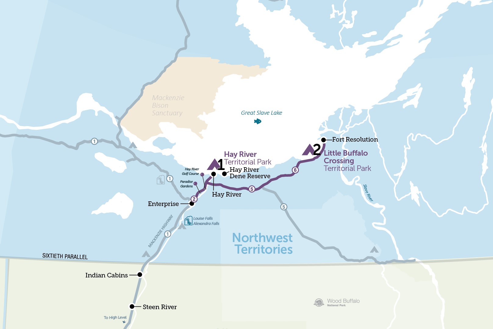
Starting in Enterprise on Highway 2, the Great Slave Route is a captivating road trip through two parks and three communities located along the southern shores of Great Slave Lake. This road trip features the sandy beaches at Hay River Territorial Park and stunning lake views in the quiet community of Fort Resolution. With fantastic fishing along the way, be sure to cast a line into the Hay River or head up river by boat at the Little Buffalo Crossing Territorial Park for excellent spring walleye fishing.
Kilometres reflect distance from Enterprise, not total driving distance.
Route Detail
Enterprise
Hit the open road
Just a stone's throw from the dramatic displays of the Hay River Gorge, Enterprise is the starting point for the Great Slave Route road trip. Take Highway 2 northeast for a classic 'hit the open road' drive.

Paradise Gardens
Market Gardens
Along the banks of the Hay River, rich soil and long summer days combine to yield bountiful vegetable, and a variety of berry crops in Paradise Gardens, the largest market gardening area in the NWT.
Hay River Territorial Park
Hay River Golf Club
The best golf course North of 60, this scenic nine-hole course is carved out of the boreal forest and set alongside the Hay River. The licensed clubhouse serves meals and drinks. Visitors are welcome.

Hay River
Located on Great Slave Lake, the community of Hay River (population 3169) began as a mission and fur trading centre in 1858. Since then, water, road, and rail transportation links have made Hay River the largest shipping centre in the North. Mackenzie River and Arctic Coast freight barging begins where the Hay River meets Great Slave Lake, giving the community the look and feel of a seaport with tugs, barges, and commercial fishing vessels busy in its waters
Of Special Interest
During the summer months, Fisherman's Wharf is host to an outdoor market each Saturday from 10am-2pm. Local vendors sell fresh fish, produce, arts and crafts, and baked goods.
Hay River Territorial Park
Located on Vale Island in the community of Hay River, the Hay River Territorial Park campground has 33 powered campsites, with both nearby wilderness and modern amenities. This park offers fantastic swimming on the sandy shores of Great Slave Lake, unique views of barges and fishing vessels plying the waters, and great opportunities to fish for northern pike.
Of Special Interest
Campsite A3 at Hay River Territorial Park has been designated as wheelchair accessible. To book, contact the Park Manager directly.


Junction of Highway 2 and 5
When leaving Hay River, turn east onto Highway 5 to travel towards Fort Resolution and Fort Smith. Continue south on Highway 2 to return to Enterprise.
Of Special Interest
There are no services between Hay River and Fort Resolution (156 km/96.9 miles) or Fort Smith (268 km/167 miles). Ensure you have sufficient fuel and any necessary supplies before leaving Hay River.
The Hay River Dene Reserve/Kátł'odeeche First Nation
Traveling eastbound on Highway 5, turn left immediately after the Hay River Bridge for the small Dene village of Kátł'odeeche First Nation/Hay River Dene Reserve. There is a small grocery store and gas station located along the main community road.
A few kilometres north of the village is the Hay River Mission Sites National Historic Site of Canada. Established in the late 19th century, the site consists of St. Peter's Anglican Church, Ste. Anne's Roman Catholic Church, informational panels, the remains of a rectory, and associated cemeteries containing spirit houses. If you visit in March the annual K’amba Carnival has a variety of entertainment, traditional games, dogsled races and crafts for all ages.

Little Buffalo Crossing Territorial Park
Buffalo Junction / Junction of Highways 5 and 6
Continue east on Highway 6 to Fort Resolution to complete the last portion of the Great Slave Route. Highway 5 to the south is the start of the Wood Buffalo Route, which ends in Fort Smith.
Kilometres reflect distance from junction of Highway 5 and 6.
Fishing adventures
Little Buffalo Crossing Territorial Park has 20 powered campsites on the shore of Little Buffalo River, just minutes away from the Great Slave Lake, the deepest lake in North America (616 metres). This territorial park is a pleasant stopping point for fishing, boating and picnicking, or as a base to explore nearby Fort Resolution.

Fort Resolution
Denı́nu Kų́ę́, / "Moose Island Place"
First located at the mouth of the Slave River, Fort Resolution (population 412) was moved to its present location in 1796 and is the oldest, continuously occupied modern settlement in the NWT. The first settlers were Cree-Metis. By 1852, Oblate priests had arrived to establish a mission and school. Treaty 8 was signed here in 1900 with the Chipewyan. Fort Resolution remained a major medical and educational centre until the 1950s. Information and walking tours of the town and boat trips to the original settlement are available at the Community Council Office, giving an insight into the history of the area and the Dene way of life.


