340 KM | Best for wood buffalo viewing
Frontier Trail
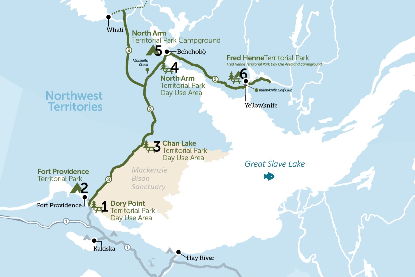
The Frontier Trail (Highway 3) takes you through rolling, polished Precambrian rock, dotted with thousands of clear lakes and rivers en route to Yellowknife, the capital city of the Northwest Territories. This road trip begins at Dory Point Territorial Park, winds around Great Slave Lake, meanders through the Mackenzie Valley Bison Sanctuary (home to the most northern population of wood buffalo) and ends in Yellowknife. There are five Territorial parks along the route for camping and day use activities.
Kilometres reflect the distance from junction of Highways 1 and 3, not the total driving distance.
Route Detail
Dory Point Territorial Park Day Use Area
Driving North
This park is a quiet picnic spot with a kitchen shelter and large parking area. It is located 2 km from the Deh Cho Bridge, south of the mighty Mackenzie River.

The Deh Cho Bridge
The Deh Cho Bridge was completed in 2012 and replaced a summer ferry and winter ice road. There are no tolls on the bridge for passenger vehicles.
Just beyond the bridge before the turn off to Fort Providence is Big River Gas Station, with fuel, a restaurant and an arts and crafts store.
Of Special Interest
There are no services along Highway 3 for another 224 km, so if you are going to Yellowknife, fuel up and ensure you have all the supplies you need.
The Mackenzie Bison Sanctuary
For the next 80 km, the area from the highway east to Great Slave Lake is set aside for wood bison to roam free. Keep a lookout and use caution as bison are frequently on or beside the road.
Of Special Interest
Treat bison with respect. They may look slow and docile but can move with amazing speed and aggression. Keep your distance. A collision can be fatal to both you and the animal.
Fort Providence Territorial Park
Fort Providence Territorial Park Campground
Fort Providence Territorial Park features 32 powered campsites and 10 powered group camping sites on the north bank of the Mackenzie River, only a 2 km drive off Highway 3. Enjoy spectacular sunsets, great fishing, and the amenities and attractions of nearby historic Fort Providence.

Historic Fort Providence
Five kilometres west of Highway 3, Fort Providence (population 797) is a scenic and historic community located on the banks of the Mackenzie River. Established in 1861 as a Roman Catholic Mission, Our Lady of Fort Providence church is a major landmark. This area has a long history as a trading post, and an excellent craft shop featuring the local specialty of moose hair tufting shouldn't be missed. West of town are two historical cairns: one commemorating Sir Alexander Mackenzie's voyage, the other acknowledging the contribution of the Grey Nuns to the community.
Chan Lake Territorial Park Day Use Area
Wildlife Haven
Located at the northern end of the Mackenzie Bison Sanctuary, Chan Lake Day Use Area is a picturesque spot for a picnic. Wildlife abounds, so watch for bison on the road, sandhill cranes in the vegetation on the roadside, and waterfowl on Chan Lake.

North Arm Territorial Park
North Arm Territorial Park Day Use Area
Stop here for a postcard-perfect view of Great Slave Lake. Be sure to look around you – the scenery dramatically shifts here, from the rocky Canadian Shield to the Mackenzie Lowlands.
North Arm Campground
Located west of Behchokò˛on Highway 3, this park sits on the shore of Great Slave Lake. There are 15 powered campsites, washrooms, picnic shelter and a playground. Enjoy the beautiful lake views and day use area during your stay.
Behchokǫ̀ / "Big Knife”
Community of Behchokǫ̀
The community of Behchokǫ̀ (population 2,154) the largest Dene community in the Northwest Territories. Located 11 km west of Highway 3, the community is the headquarters of the Tłı̨chǫ Region and plays host various Dene cultural celebrations and events each year. The community features some unique modern architecture that takes design cues from the traditional caribou hide lodge or teepee. There is a gas bar, restaurant, grocery store, and bed and breakfast accommodations.
Of Special Interest
The Yellowknife Golf Club is just off the highway to the north and is an 18-hole golf course with sand fairways, artificial greens, pro shop, and licensed clubhouse. It is home to the famous Midnight Classic Golf Tournament each June.

Fred Henne Territorial Park
Day Use Area
A roadside turn-out to the north provides access to this popular recreational area on the shores of Long Lake, one of the best beaches in the Territories. This day use area has picnic sites, a boat launch, kitchen shelters, a sandy beach, a playground, and change houses. On the smaller side, Long Lake warms up enough in the summer to make it a favourite place for water activities, including swimming, boating, tubing, water skiing, windsailing, and jet skiing.

Campground
The largest Territorial park campground, Fred Henne offers 75 powered and 40 non-powered sites (including 9 tent pads). This park is the perfect spot for swimming and other water spots, as well as enjoying the amenities and attractions of Yellowknife, located just 3 km away.
Of Special Interest
There is an excellent 4 km hiking trail that starts just to the left of the shower building. Prospectors' Trail will take you around several fascinating geological features.

Junction of Highways 3 and 4
Continue on Highway 3 to reach Yellowknife or turn left to visit Territorial parks on the Ingraham Trail.
Yellowknife
The Capital
Yellowknife (population 20,960) is a modern city, with shopping facilities and all the services you would expect to find in other Canadian cities. Located on the shores of the beautiful Great Slave Lake, Yellowknife is an unusual blend of many southern and northern cultures. It is a city of contrasts, with modern high-rise towers overlooking the rustic heritage buildings of Old Town. There is easy access to fishing, canoeing, hiking, camping, golfing and nature viewing and tour packages are easy to arrange. Annual summer events include an arts festival, folk music festival, and golf tournaments. The city also features many parks and playgrounds, a racquet club, curling rink, pool, movie theatre and golf course.
