840 KM | Best for adventures of a lifetime
Dempster Highway
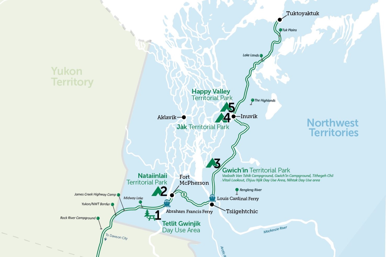
Follow the rugged gravel Dempster Highway through the Artic Circle and visit the northernmost Territorial Parks, home to some of the most beautiful wilderness in the world. The Dempster Highway stretches 740 km through the Tombstone, Ogilvie and Richardson Mountain Ranges in the Yukon, before entering the Northwest Territories. The route begins 40 km east of Dawson City, Yukon and ends at the Arctic Ocean in Tuktoyaktuk, Northwest Territories. Completed in 1978, the Dempster is the only public highway in Canada to cross the Arctic Circle.
The phenomenal beauty and remoteness of this highway makes it a major focus for travellers looking to get off the beaten path. Information about the route and highway conditions is available at the Dawson City Visitor Information Centre on Front Street.
Kilometres reflect distance from the beginning of the Dempster Highway in the Yukon, at the junction of Highway 2 (Klondike Highway) and Highway 5 (Dempster Highway), not total driving distance.
When crossing into the NWT, the Dempster Highway becomes NWT Highway 8. Gasoline, diesel and propane services are available at Fort McPherson, Inuvik, and Tuktoyaktuk (no propane in Tuktoyaktuk) in the Northwest Territories.
Route Detail
The Yukon
Tombstone Mountain Campground
One of the four road-accessible campgrounds, there are 30 reservable campsites at Tombstone Mountain Campground. This campground is often used as a base for either driving the Dempster Highway or hiking in Tombstone Territorial Park.
Of Special Interest
A viewpoint of the eponymous Tombstone Mountain is just 3 km past the campground.
North Fork Pass
The highest elevation along the Dempster Highway at 1,298 metres/4,229 feet, North Fork Pass marks the continental divide between the Yukon and Mackenzie River system.
Commemorative Plaque
The Royal North-West Mounted Police trekked this country on their monthlong patrols from Dawson to Aklavik. This plaque commemorates the career of William John Duncan Dempster, a Welshman who emigrated to Canada and served in various communities in the North. Considered "the best trail man in the Yukon", Sgt. Dempster led more northern patrols than any other member of the RNWMP and was eventually tasked with making the patrol route safer.
Engineer Creek Campground
Situated below Sapper Hill, a collection of dolomite cliffs, the Engineer Creek Campground has 11 campsites, kitchen shelters, outhouses, and other amenities.
Ogilvie River Bridge
The Dempster Highway leaves the river valley at Kilometre 242 and begins to climb again some 915 metres/3,000 feet into the continental divide and through the rolling Eagle Plains.
Of Special Interest
At Kilometre 259, the Ogilvie-Peel Viewpoint provides a sweeping view across the river valley to the northern Ogilvie Mountains.
Drunken Forest
Permafrost action has heaved the ground under a patch of jack pine and black spruce, causing them to lean and tilt.
Eagle Plains Hotel and RV Campground
Marking the halfway point between Dawson City and Inuvik, the Eagle Plains Hotel is open year-round, offering a licensed restaurant and lounge, full-service garage, RV park, laundromat, and 15-site campground.
The Arctic Circle
Just beyond Eagle Plains, the Dempster highway crosses the Arctic Circle. One of the globes two polar circles, and the most northerly of the five major circles of latitude. Bask in 24 hours of daylight for six weeks during summer. Make sure you take your picture at the signpost!
Rock River Campground
Nestled within a steep gorge of the Richardson Mountains, Rock River Campground is the perfect place for a picnic or to pitch a tent overnight on your travels.
Wright Pass Summit
The last high point on the highway before travellers cross into the Northwest Territories.
NWT Border Crossing & Nataiinlaii Territorial Park
The Northwest Territories
Welcome to the NWT! The Dempster Highway crosses the continental divide for a third time as it winds through the Richardson Mountains at the border of the Yukon and Northwest Territories. A rest stop and interpretive display mark the border crossing.
James Creek Highway Camp
James Creek Highway Camp has good grayling fishing but no services.
Midway Lake
Midway Lake plays host to the annual Midway Lake Music Festival held each year on the August long weekend.
Tetlit Gwinjik Day Use Area
Nestled on the north-facing slope of the Peel River Plateau, the interpretive lookout at this day use area gives a sweeping view of the Richardson Mountains, the Mackenzie Delta and the community of Fort McPherson on the banks of the Peel River.
The Abraham Francis Ferry – Peel River Crossing
The ferry operates on demand, daily from 9:15 am - 12:45 am from early June to mid-October. During the winter an ice road replaces the ferry. Crossing the river is not possible during spring ice break-up and fall river freeze-up. Check current river crossing conditions online or call 1-800-661-0750.
Nataiinlaii Territorial Park
Nataiinlaii Territorial Park features 22 non-powered sites surrounded by stands of white birch and white spruce trees and perched on a cliff overlooking the Peel River. Park amenities include a group camping area, picnic shelter, and a shower building. The log Visitor Information Centre provides a fascinating glimpse of the life of the Gwich'in people, past and present. Online reservations are not available for this park, please register upon arrival at the Visitor Centre. Sites are available on a first come, first served basis (campsites are generally available).

Fort McPherson
Fort McPherson (population 791) is a picturesque community located in the Mackenzie Delta and home to the Tetlit Gwich'in people and is a popular stopping place for travellers heading for the end of the Dempster Highway. Visit the Fort McPherson Tent and Canvas Company, world famous for their prospector tents, tipis and sturdy duffel bags. Visit the graves of the Lost Patrol of the Royal Northwest Mounted Police.
The Louis Cardinal Ferry – Mackenzie River and Arctic Red River Crossing
The ferry operates daily from 9:30 am - 12:45 am from early June to mid-October and operates based on demand. The ferry travels across the Mackenzie River and provides access to Tsiigehtchic. Advise ferry staff if you would like to go to the community. In winter, an ice road replaces the ferry. Crossing the river is not possible during spring ice break-up and fall river freeze-up. Check current river crossing conditions online or call 1-800-661-0750.
Tsiigehtchic
Tsiigehtchic (population 177) is located at the confluence of the Arctic Red and Mackenzie Rivers. Most of the Gwichya Gwich'in inhabitants of Tsiigehtchic—meaning "mouth of iron river"—still follow a traditional lifestyle of hunting, fishing, and trapping.
Gwich'in Territorial Park
Unbounded Wilderness
The Dempster Highway serves as a boundary for the 8,800-hectare Gwich'in Territorial Park and connects visitors to two campgrounds, two day use areas, a scenic lookout and a hiking trail. The park is home to a number of natural heritage wonders of the Mackenzie Delta.
Vadzaih Van Tshik Campground
Nine non-powered sites are nestled on the side of Caribou Creek, well protected from the elements by a steep cliff on the north side of the creek. Online reservations are not available for this park; please obtain a permit at the on-site self-registration kiosk. Sites are available on a first come, first served basis (campsites are generally available).
Tithegeh Chii Vitaii Lookout
A short walk from the highway takes you to the edge of the cliffs overlooking Campbell Lake where peregrine falcons are commonly seen. There is also approximately half a kilometre of walking trails to enjoy.
Gwich'in Territorial Campground
Facilities at this campground include 25 non-powered campsites and 11 tent sites located on the spectacular shoreline of Campbell Lake.


Ehjuu Njik Day Use Area
Spend the afternoon at Ehjuu Njik Day Use Area picnicking at Cabin Creek or cast your line for Arctic grayling.

Nihtak Day Use Area
This day use park provides an access point to Campbell Lake at the foot of the Dolomite Hills. During the spring water runoff, large numbers of whitefish migrate up the creek to spawn. Spend the day picnicking and absorbing the panoramic scenery.

Jàk Territorial Park
The "Berry" Best Place
Just outside of Inuvik, the park has 10 powered and 26 non-powered sites. An observation tower offers excellent views of the surrounding scenery and prime bird watching opportunities. Watch for falcons, eagles, ducks, and more. Forage for the cranberries, blueberries, and cloudberries that give the park its name – Jàk means "berry" in Gwich'in.

Inuvik
"Place of People"
Inuvik (population 3,170) is the largest community in this region, the last traditional stop on the Dempster Highway, and start of the Inuvik to Tuktoyaktuk road. A modern Arctic community, Inuvik has full visitor services, including boat and air tours to other communities and to sites of interest in the Mackenzie Delta. Located 220 km north of the Arctic Circle, Inuvik experiences the true Midnight Sun for the 57 days between May 24 and July 24 when the sun does not set. This is contrasted by about 30 days (December 5 to January 5) when the sun does not rise above the horizon, providing just four hours a twilight each day.
Happy Valley Territorial Park
Wilderness Camping, Modern Amenities
Located in the town of Inuvik, this park is conveniently close to the town's facilities and attractions. There are 19 powered and 15 non-powered sites as well as a group tenting site. Situated on a bluff overlooking the east branch of the Mackenzie River, the park has wonderful views of the Richardson Mountains.

Inuvik to Tuktoyaktuk Highway
Highway 10
Head north from Inuvik to the Arctic Ocean in Tuktoyatuk. The journey is filled with incredible views of hundreds of lakes and sweeping views of the Mackenzie River Delta, all capped off with the ability to drive right to the shores of the Arctic Ocean. There are eight pull-out rest areas located along the journey to stretch your legs. The Inuvik to Tuktoyaktuk Highway can be categorized into three zones: Highlands, Lake Lands, and the Tuk Plains.
The Highlands
The Highlands section of the Inuvik to Tuktoyaktuk highway passes through the Caribou Hills and is characterized with stunted tree growth (poplar, birch and white spruce). Midway through the Highlands, travellers will cross into the fall migration zone of both the Bluenose West and Cape Bathurst caribou herds. There are four bridge crossings at kilometres 2.5, 8.4, 26.1, and 40.4. There are three pull-out rest areas at kilometres 29, 30, and 41.
Lake Lands
The Lake Lands section of journey is a transitional zone between the Caribou Hills and the Tuktoyaktuk coastal plains and begins at approximately kilometre 52. It contains two bridge crossings (kilometre 57.3 and 69.1), and two pull-out rest areas at kilometre 62 and 71. The drive will take you past two major lakes: the picturesque Parson's Lake and the scenic Husky Lake. The vegetation throughout this transitional zone is varied, with tundra shrubs and small stunted trees that typically grow in the sheltered lowland river valleys.
The Tuk Plains
The Tuk Plains is a breathtaking section of the highway characterized by low shrubby vegetation, hundreds of lakes and the Beaufort-Delta pingos. Steeped in tradition and history, the area is home to many significant Indigenous cultural sites. The area is also actively used by caribou and grizzly bears; caribou herds migrate through this zone during the fall rut and grizzly bears use the area for denning over the winter. Stop and absorb the unique views of the Tuk Plains at one of three highway pull-outs located at kilometres 107, 103, and the Pingo pull-out rest area located three kms from the Hamlet of Tuktoyaktuk.
Tuktoyaktuk
"Tuk"
On the shores of the Arctic Ocean sits the peaceful hamlet of Tuktoyaktuk (pop. 898). The hamlet's name, Tuktoyaktuk, or Tuktuuyaqtuuq (Tuk), is the traditional name from the Inuvialuit language and is translated as "place resembling a caribou". Today, it is commonly referred to simply as Tuk. The hamlet has two gas stations (but no propane), two grocery stores, and a handful of other amenities, including guided tours.
Pingo National Landmark
Unique to the hamlet of Tuktoyaktuk is the famous the Pingo Canadian Landmark, just 5 km west of Tuktoyaktuk. Pingos are unique geological features formed in specific permafrost conditions. To access the viewing boardwalk, launch your canoe/kayak at the Day Use Area beach and paddle west towards the pingos for 30 to 40 minutes. The Tuktoyaktuk Canoe Club will lend out their canoe(s) to responsible visitors.