220 KM | Best for sweeping mountain views
Liard Trail
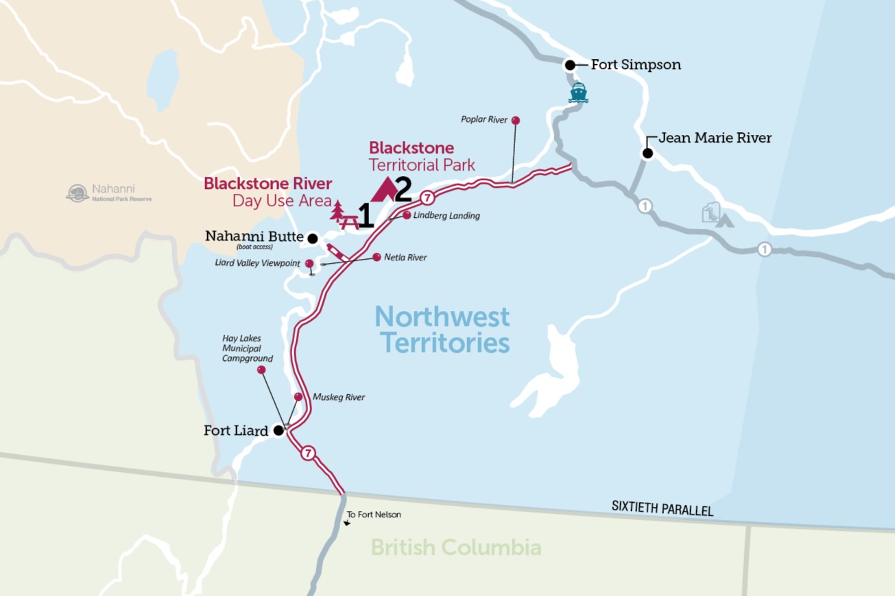
This route starts at the Northwest Territories/British Columbia border and takes you northeast, following the scenic river valley through Fort Liard northeast along highway 7. It features inspiring views of the Liard River and the Nahanni Mountains, and travelers can visit the Blackstone Territorial Park, the only territorial park on this route.
Highlights along the route, include fishing spots like Muskeg and Poplar Rivers, and the culturally rich community of Nahanni Butte. The route offers diverse experiences from the rugged natural beauty of the Nahanni National Park Reserve to the rustic charm of Hay Lakes campground.
Kilometres noted reflect the distance of the point from the NWT/BC border, not total driving distance.
Route Detail
NWT/BC Border
Welcome to the NWT
The iconic border sign will let you know you've entered the Northwest Territories.

Fort Liard
The Tropics of the North
Nestled in the foothills of the Mackenzie Mountains, the 'tropics of the North' is home to the warmest weather and best growing conditions in the Territories. The Hamlet of Fort Liard is also one of the oldest continuously settled areas in the North, with the local Deh Gáh Got’îê Dene having inhabited the area for 10,000 years.
This small community (population 615) is located 6.4 km west of the Liard Highway, at the confluence of the Liard and Petitot Rivers. The view of the rivers and mountains from the access road and the community are well worth the short side trip. There is also a visitor information centre, with traditional crafts and an ice cream shop - the perfect combination!
Of Special Interest
Fort Liard is home to the Acho Dene, renowned for their birchbark and porcupine quill artistry. It's the perfect place to buy traditional Dene arts and crafts, from bowls and mukluks to birchbark baskets (the local speciality).
The Liard Valley Viewpoint at kilometre 77 offers a small rest area with a postcard-perfect view of the Liard Valley and the Liard Mountain Range.
At kilometre 115.9, the Netla River is an important waterfowl breeding habitat with gorgeous views of the mountains on the opposite side of the Liard River.
Muskeg River
A popular swimming hole for local residents, this is also a good spot for fishing for pike, pickerel/walleye, and freshwater clams. You will find a turnout with interpretive signage at north end of the stop.
Hay Lakes Municipal Campground
Located just a couple hours drive from the Alaska Highway and only 4 km from the access road to Fort Liard, the Hays Lake Municipal Campground is a scenic spot for camping or to stop for a trail walk. Wildlife, including beaver and the occasional bison, are residents of the area. Situated next to a small lake, the campground it has a kitchen shelter and several campsites.
Nahanni Butte
Tthenáágó / "Strong Rock"
This small Dene community (population 92), at the confluence of the South Nahanni and Liard Rivers, is the entrance point for the Nahanni National Park Reserve. It is accessible in summer by boat, aircraft, or floatplane. Contact the Nahanni Butte Dene Band to arrange a boat taxi (867) 602-2900. In the winter an ice bridge connects Nahanni Butte to the Liard Highway across the river.
Contact the Nahanni Butte Dene Band at 867-602-2900 to arrange for a boat taxi to take you to Nahanni Butte.
Nahanni National Park Reserve
Established in 1976, the Nahanni National Park Reserve protects a portion of the Mackenzie Mountains Natural Region. With dazzling natural beauty at every turn, the centerpiece of the park is the South Nahanni River. Four noteworthy canyons, reaching 1,000 metres in depth, line this spectacular river. At Virginia Falls, the river drops an incredible 96 metres, nearly double the vertical drop of Niagara Falls. The South Nahanni region offers spectacular hiking opportunities, mostly by boat from the river corridor. The majority of visitors travel to the park by chartered float plane via Fort Simpson or Yellowknife.
You must request a reservation through Parks Canada if you intend to stay overnight in Nahanni National Park Reserve. As camping space is limited in order to protect the environmental and cultural significance of the area, it is recommended you request a reservation as far ahead as possible.

Blackstone Territorial Park
Blackstone River Day Use Area
A picturesque rest stop and picnic area overlooking the copper-toned Blackstone River, this day-use spot is ideal for resting, stretching your legs, and enjoying the wilderness while traveling along the Liard Trail.
Blackstone Territorial Park
Blackstone Territorial Park is located at the convergence point of the Peace, Liard, and Mackenzie Rivers. The area is rich in historical significance, alive with abundant wildlife and framed by stunning mountain views. With a comfortable campground and lots of moving water, it is an excellent starting or ending point for canoeing, boating and fishing on the South Nahanni, Liard and Blackstone Rivers. The visitor information building, constructed with local timbers, is open from mid-May to the end of September.
Of Special Interest
The only territorial park on the Liard Trail, Blackstone has an interpretive centre that tells the history of the First Nations of the area, features stories of local adventurers, as well as information about weather and current river conditions.
Lindberg Landing
The Landing
Follow the Liard Trail west to the small homestead of Lindberg Landing on the shore of the Liard River. This location has served as a landing site for travelers on the South Nahanni and Liard Rivers for many decades.
Poplar River
A Fishing Haven
Pull over, stretch your legs, and cast your line into Poplar River for some Arctic grayling and pike.

